
Commons:Graphic Lab/Map workshop
| Illustration Workshop | Map Workshop | Photography Workshop | Video and Sound Workshop |
 Map workshop
This workshop is part of the Graphic Lab, a project aimed at picture retouching to improve the graphical content of the Wikimedia projects. More information about the lab can be found on its main page and requests pages (Illustrations ; Photographs ; Maps ; Video and Sound). To ask questions or make a suggestions, see the talk page of the graphic lab page.
This specific page is the requests page for the Map Workshop. Anyone can make a request for a map to be created or improved. The standard format for making a request is shown below, along with general advice, and should be followed.
Make a request
Use the following template when making a new request, replacing the examples with your image(s) and request(s):
<gallery>
 IMAGENAME.EXT|Description of image
 IMAGE#TWO.EXT|2nd image (If there is one)
 ETCETCETC.EXT|Don't request too many at once, though
</gallery>

;Request:
: Details of your request go here… --~~~~
;Graphist opinion(s):
See also
[edit] |
SpBot archives all sections tagged with {{Section resolved|1=~~~~}} after 7 days and sections whose most recent comment is older than 185 days. For the archive overview, see /Archive. The latest archive is located at /Archive/2025. |
Russia Map Border
[edit]-
 Moscow boundaries need to be updated, they are outdated.

Article(s): Jewish Autonomous Oblast
- Request
- Moscow's boundaries need to be updated, they are outdated. --– Illegitimate Barrister (talk • contribs), 21:37, 4 August 2024 (UTC)
- Graphist opinion(s)
- Given this is likely an issue across all theoretically current Russian administrative border maps, it might be best to create a category to put maps needing an update in. CMD (talk) 13:59, 9 December 2024 (UTC)
- @Illegitimate Barrister Also you would need to specify what to edit to what. --please ping me-- Goran tek-en (talk) 15:58, 5 May 2025 (UTC)
Map used in around 80 articles (improvement/correction)
[edit]-
Map of early historic south India
-
 Periplous of the Erythraean Sea locations

Article(s): Around 80 articles
- Request
- 1. Map of early historic south India - kindly remove the internal borders from the map (as they are largely estimations - locations of various ancient polities or tribes). Please smudge the lines or something. 2. Periplous of the Erythraean Sea locations - This image looks incredibly amateur. Kindly remove the strange white fog all over the image. Please make this a professional map. --JamesMdp (talk) 14:58, 23 February 2025 (UTC)
- Graphist opinion(s)
- @JamesMdp: You have two request for this map here, it's really confusing, please join them to one.
- On your other request I have written some information for you and here below is a copy of it:
- This might be an explanation why it's hard to get someone to work on this.
- That file is not a true svg, there is a bitmap included in it (to show the topography, etc). The mist you are talking about is white to cover the bitmap so the legend is more legible. The svg file it self has a lot of clipped objects, so it's a really complicated file to edit or work in and then there are also several langues within the file.
- So for me, I would not edit or work on that file. My only solution would be to create a new map, a version of this and leave this as it is, then people can use which version they like. --please ping me-- Goran tek-en (talk) 16:45, 14 July 2025 (UTC)
- Thanks... JamesMdp (talk) 09:44, 30 September 2025 (UTC)
Maps of the Principality of Monaco
[edit]- Request
- All maps of the Principality of Monaco should now feature the new Mareterra district, built on the sea and opened to the public in December 2024. --InfattiVedeteCheViDice (talk) 08:52, 23 January 2025 (UTC)
- Graphist opinion(s)
- The district was opened as Le Portier. Mareterra was the name at time of construction. --Minoa (talk) 01:51, 4 August 2025 (UTC)
Vectorize raster map files
[edit]-
 Raster map 1
 -
 Raster map 2
 -
 Raster map 3
 -
 Raster map 4


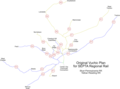
Article(s): en:SEPTA Regional Rail, en:SEPTA, en:PATCO Speedline, and en:Delaware Valley Regional Planning Commission
- Request
- Hi! Please vectorize these four raster map files. Please add Franklin Square station to the third map since it will be reopening next month. Thank you! --OrdinaryScarlett (talk) 11:46, 3 March 2025 (UTC)
- Graphist opinion(s)
 Request taken by --please ping me-- Goran tek-en (talk) 13:10, 3 September 2025 (UTC)
- @OrdinaryScarlett I do need your knowledge on this request, it's a bit hard to understand what is what.
- On this page there a some maps (pdf's), could you tell me which is the correct for each of the three Raster maps you supplied above?
- Please also tell what exactly what that I need is named in the legends, thanks?
- On this page there a some maps (pdf's), could you tell me which is the correct for each of the three Raster maps you supplied above?
- --please ping me-- Goran tek-en (talk) 14:05, 3 September 2025 (UTC)
- @Goran tek-en: For the first raster map, the first PDF is fine, just focus only on the thin-blue lines. File:SEPTA Regional Rail Diagram.svg is a good resource for telling which lines are former Pennsylvania Railroad lines (red) and former Reading Railroad lines (blue). The yellow on the raster map corresponds to the blue on the vector map, and the blue on the raster map corresponds to the red on the vector map. The legend should describe which lines are for Pennsylvania Railroad lines and which are former Reading Railroad lines. For the second raster map, you can vectorize the geographic boundaries as-is. Everything can be vectorized as-is, but for the light rail and rapid transit lines in the second raster map, you could use the colors from the second PDF map and the names "B", "L", "M", "D", (and maybe even add the "T" lines, see the interactive map in the infobox for the en:T (SEPTA Metro) article) or alternatively, just vectorize the entire map as-is if that's easier. The third raster map can be vectorized as-is, but just needs a station named "Franklin Square" (could alternatively be shortened to "Franklin Sq") on the curve just north of 8th & Market. For that one you could use the second PDF map, but just focusing exclusively on the red line to see what I mean. The fourth one can be vectorized as-is. OrdinaryScarlett (talk) 18:01, 4 September 2025 (UTC)
SEPTA
[edit]@OrdinaryScarlett: I'm sorry if I ask you too much but there are so many ways a map like this can be created.
- If you want a straight "copy" of your first raster map, just say so.
- Draft septa-1 is to give you an idea of what I'm thinking of doing.
- I haven't put in all the stations, do you want that?
- As I understand it, all the lines now has one operator and they don't have different colors to separate them. We can either have different colors or the same color but different types of lines?
Ones again, I'm sorry if I over complicate this, just tell me if so, thanks. --please ping me-- Goran tek-en (talk) 18:30, 6 September 2025 (UTC)
- @OrdinaryScarlett: I do need your feedback, thanks. --please ping me-- Goran tek-en (talk) 15:48, 10 September 2025 (UTC)
- @Goran tek-en: My apologies for the delay! I was preoccupied with other things. Yes, a straight "copy" is perfect for this one. OrdinaryScarlett (talk) 00:40, 12 September 2025 (UTC)
- @OrdinaryScarlett
- The colors a picked to work well for people with color deficiency.
- Draft SEPTA-2 --please ping me-- Goran tek-en (talk) 15:09, 12 September 2025 (UTC)
- @Goran tek-en: Looks fantastic! OrdinaryScarlett (talk) 00:18, 13 September 2025 (UTC)
- @OrdinaryScarlett:
 Question *What about that little green part, should it be in the legend and if so what text?
- Then I will need the following;
- Name of the file
- Description (/language)
- Captions/s (/language)
- Category/ies at commons
- Structured data/Items portrayed in this file, the Q#, to be able to upload it at commons, thanks. --please ping me-- Goran tek-en (talk) 14:08, 13 September 2025 (UTC)
- @Goran tek-en: Regarding the little green part, I think including it in the legend would be helpful with the text "Center City Commuter Connection". For the name of the file, by reusing the raster file name, "File:Vuchic SEPTA plan.svg". For the description, reusing the original raster file's description, "The original Vuchic plan for SEPTA Regional Rail." Captions are unnecessary. Categories at Commons could include "SEPTA maps" and "SEPTA Regional Rail". Structured data could include "SEPTA Regional Rail". OrdinaryScarlett (talk) 02:30, 15 September 2025 (UTC)
- @OrdinaryScarlett
- Now you can find it here file:Vuchic SEPTA plan-svg.svg.
- Please check all the information, also links for wikipedia, wikidata and structured data.
 Done --please ping me-- Goran tek-en (talk) 14:02, 15 September 2025 (UTC)
- @Goran tek-en: Thank you so much! Everything looks good - I've gone ahead and replaced the raster file version with it in the subsequent article. I did remove the extra "-svg" from the name since the formatting is already there. OrdinaryScarlett (talk) 17:26, 15 September 2025 (UTC)
- @OrdinaryScarlett I add that extra svg when I make a copy of a bitmap into the name so when you have a thumbnail with the caption text below, it is much clearer that this is the svg version. If you have the exact same name you don't really know if it's a bitmapp or svg.
- So to me it is important information. --please ping me-- Goran tek-en (talk) 11:22, 16 September 2025 (UTC)
- @Goran tek-en: Ah, my apologies. I see your point. I've gone ahead and restored it. OrdinaryScarlett (talk) 16:49, 17 September 2025 (UTC)
- @Goran tek-en: Thank you so much! Everything looks good - I've gone ahead and replaced the raster file version with it in the subsequent article. I did remove the extra "-svg" from the name since the formatting is already there. OrdinaryScarlett (talk) 17:26, 15 September 2025 (UTC)
- @Goran tek-en: Looks fantastic! OrdinaryScarlett (talk) 00:18, 13 September 2025 (UTC)
- @Goran tek-en: My apologies for the delay! I was preoccupied with other things. Yes, a straight "copy" is perfect for this one. OrdinaryScarlett (talk) 00:40, 12 September 2025 (UTC)
- @OrdinaryScarlett: I do need your feedback, thanks. --please ping me-- Goran tek-en (talk) 15:48, 10 September 2025 (UTC)
Rail system
[edit]@OrdinaryScarlett: So how do you want this, straight copy or what?
- @Goran tek-en: Yeah, a straight copy is fine here, though with some changes:
- Under the "Light Rail & Rapid Transit" subbox in the "Legend" box (they could also be rearranged in this order under this subbox):
- "Market-Frankford Line" could be shortened to "L". The corresponding blue line next to the text and on the map could be adjusted to hex code #1c9ad6.
- "Broad Street Line" could be shortened to "B". The corresponding orange line next to the text and on the map could be adjusted to hex code #f26100.
- "Pattison" at the end of the orange line on the map should be changed to "NRG".
- "T" could be added at the legend with a corresponding green line next to the text and on the map with the hex code #5a960a. The routing can be found at the interactive infobox map on en:T (SEPTA Metro).
- "G" could be added at the legend with a corresponding yellow line next to the text and on the map with the hex code #fcd602. The routing can be found at the interactive infobox map on en:G (SEPTA Metro).
- "Media & Sharon Hill Lines" could be shortened to "D". The corresponding brown line next to the text and on the map could be adjusted to hex code #e5427b.
- "Route 100 (P&W)" could be shortened to "M". The corresponding pink line next to the text and on the map could be adjusted to hex code #613393.
- The dotted pink line corresponding to the "P&W Strafford Branch" next to the text in the legend and on the map could also be adjusted to hex code #ef3e42.
- "PATCO High-Speed Line" could be shortened to "PATCO Speedline". The corresponding red line next to the text and on the map could be adjusted to hex code #ef3e42.
- "NJT RiverLINE" could be adjusted to "NJT River Line" for ease of reading. The corresponding purple line next to the text and on the map could be adjusted to hex code #00a5e3.
- Other map changes:
- The black line that ends at "Elwyn" should be extended slightly to the left to end at "Wawa". An interactive map showing where the line ends at Wawa can be found in the infobox on the article en:Media/Wawa Line.
- The black line that ends at "Thorndale" could be extended slightly to the left to end at "Coatesville". Technically this extension isn't open yet, but is planned to very soon, so showing it open now should hopefully avoid future headache. An interactive map showing where the line will end at Coatesville can be found at the article en:Coatesville station with coordinates.
- OrdinaryScarlett (talk) 03:20, 15 September 2025 (UTC)
- @OrdinaryScarlett
- Thank you for being so organized with the information I need, it helps a lot.
- There is a father green line in this draft. I can't find it in the legend and the dashes doesn't fit any other, so what is it?
- Draft rail system-1 --please ping me-- Goran tek-en (talk) 16:32, 17 September 2025 (UTC)
- @Goran tek-en: No problem!
- Looking into the highlighted green line on your draft, it's the en:Stony Creek Branch. It's a still-active freight-only branch owned by SEPTA, over which freight railroads have trackage rights.
It could probably get its own unique dash on the map and in the legend, which I'll leave up to you. - Just an FYI, though, based on what I saw in the first draft, there should be spaces between "Light Rail", "&", and "Rapid Transit" in the legend.
I also noticed that you put "Other Railroads" under "Abandoned Lines" instead of under "Railroad Lines". "Other Railroads" should be moved back under "Railroad Lines"; these other railroads aren't abandoned, they just don't host any passenger services.- Yeah, taking a look at the map, I'm just realizing now the hex code I picked for the "NJT River Line" doesn't contrast well from the "L". I think using #164634 for the "NJT River Line" instead should be better for contrasting the two.
- On second thought, I also think using a slightly darker hex code for the PATCO Speedline (#c81f3c) would look a little better.
Would it be alright if you could make the "P&W Strafford Branch" on the map and in the legend use the same hex code as the "M" (#613393) since it's basically an abandoned branch of that system?
- Looking into the highlighted green line on your draft, it's the en:Stony Creek Branch. It's a still-active freight-only branch owned by SEPTA, over which freight railroads have trackage rights.
- Again, thank you for your hard work on these maps, they look great! OrdinaryScarlett (talk) 17:43, 17 September 2025 (UTC)
- @Goran tek-en: I think you should remove all the dashed lines.
- I took another careful look at the original raster map again, and in my opinion, what it includes in the dashed line categories is a bit... subjective and inconsistent. In the "Other Railroads" category, it includes both active and disused railway rights-of-way, which is misleading for average readers. Besides; this map is a far cry from including all of the railway rights-of-way within its purview, active and disused. It includes the "West Chester Trolley", which corresponds with en:SEPTA Route 104, yet confusingly omits en:SEPTA Route 103.
- Frankly, I think the original raster map is trying to do too much by showing both current rail services in the greater Philadelphia area, along with a bunch of non-passenger corridors, both current and historical. Tourist railroads also aren't really public transit in the same vein as everything else depicted on this map.
- It ultimately creates a map that's very bloated, inconsistent, and anachronistic in what it's attempting to portray. It's really not useful for an average user who probably just wants a static map to view how current rail transit interacts with each other around the region, not any extraneous visual information.
- So, frankly, I think to keep the map focused, and to prevent any further hassle and research in terms of which railway lines go where, I think all of the dashed lines should be axed completely. That would include "Tourist Railroads" "Other Railroads", "P&W Strafford Branch", "West Chester Trolley", and the green line you highlighted to me (the en:Stony Creek Branch), as well as all those city names located exclusively along those corridors. OrdinaryScarlett (talk) 03:25, 18 September 2025 (UTC)
- @Goran tek-en: Sorry for the excessive pings! One last thing, I think adding "SEPTA" before "L", "B", "T", "G", "D", and "M" in the legend box on the right side should help readers distinguish which services are operated by each transit operator, since not all services on this map are operated by SEPTA. OrdinaryScarlett (talk) 04:10, 18 September 2025 (UTC)
- @OrdinaryScarlett
- Draft rail system-2
- I think using #164634 for the "NJT River Line": That color is almost black, sure about the hex, I changed to #00cde3ff, OK?
- I added a ":"after SEPTA as it was hard to understand without.
- --please ping me-- Goran tek-en (talk) 12:54, 18 September 2025 (UTC)
- @Goran tek-en: It looks fantastic! Thank you! OrdinaryScarlett (talk) 18:42, 18 September 2025 (UTC)
- @OrdinaryScarlett
- Regarding the colors you have giving. Are they absolut what you want, because they don't really work for people with color deficiency and I always try to create maps that also work for them if possible.
- So if they are not absolut for you I can show you a draft that will work?
- I will need the following;
- Name of the file
- Description (/language)
- Captions/s (/language)
- Category/ies at commons
- Structured data/Items portrayed in this file, the Q#, to be able to upload it at commons, thanks.
- --please ping me-- Goran tek-en (talk) 11:11, 19 September 2025 (UTC)
- @Goran tek-en: Sure! Feel free to show me a color deficiency-friendly version. If that's preferable, then sure!
- Name: File:Philadelphia Transit and Commuter Rail System.svg
- Description (en): Geographic map of the Philadelphia region rail system.
- Captions: N/A
- Categories at Commons: SEPTA maps
- Structured data: SEPTA, SEPTA Regional Rail, SEPTA Metro
- OrdinaryScarlett (talk) 18:43, 19 September 2025 (UTC)
- @OrdinaryScarlett Draft color-1 --please ping me-- Goran tek-en (talk) 11:19, 23 September 2025 (UTC)
- @Goran tek-en: Looks good! OrdinaryScarlett (talk) 18:33, 23 September 2025 (UTC)
- @OrdinaryScarlett Now you can find it here Philadelphia Transit and Commuter Rail System-svg.
- Please check all the information, also links for wikipedia, wikidata and structured data.
- Done --please ping me-- Goran tek-en (talk) 11:16, 24 September 2025 (UTC)
- @Goran tek-en: Everything looks good! OrdinaryScarlett (talk) 19:04, 24 September 2025 (UTC)
- @Goran tek-en: My bad, just noticing that you mismatched the two colors in the legend box with their corresponding map colors for the "SEPTA: B" and the "PATCO Speedline." Everything else looks good! OrdinaryScarlett (talk) 19:10, 24 September 2025 (UTC)
- @OrdinaryScarlett Don't understand, tell me what to change to what. --please ping me-- Goran tek-en (talk) 20:11, 24 September 2025 (UTC)
- @Goran tek-en: Inside the box, you put brown next to "SEPTA: B" and teal next to "PATCO Speedline". On the map, you used teal for "SEPTA: B" and red for "PATCO Speedline". There is a mismatch between the colors next to these two line names inside the box and the colors on the map as a whole. They need to be rematched. OrdinaryScarlett (talk) 20:33, 24 September 2025 (UTC)
- @OrdinaryScarlett
- Draft rail-4, is this correct? --please ping me-- Goran tek-en (talk) 12:08, 25 September 2025 (UTC)
- @Goran tek-en: Yup! OrdinaryScarlett (talk) 17:53, 25 September 2025 (UTC)
- @OrdinaryScarlett Done --please ping me-- Goran tek-en (talk) 10:16, 26 September 2025 (UTC)
- @Goran tek-en: Thank you so much! OrdinaryScarlett (talk) 19:58, 26 September 2025 (UTC)
- @OrdinaryScarlett
- @Goran tek-en: Yup! OrdinaryScarlett (talk) 17:53, 25 September 2025 (UTC)
- @Goran tek-en: Inside the box, you put brown next to "SEPTA: B" and teal next to "PATCO Speedline". On the map, you used teal for "SEPTA: B" and red for "PATCO Speedline". There is a mismatch between the colors next to these two line names inside the box and the colors on the map as a whole. They need to be rematched. OrdinaryScarlett (talk) 20:33, 24 September 2025 (UTC)
- @OrdinaryScarlett Don't understand, tell me what to change to what. --please ping me-- Goran tek-en (talk) 20:11, 24 September 2025 (UTC)
- @Goran tek-en: My bad, just noticing that you mismatched the two colors in the legend box with their corresponding map colors for the "SEPTA: B" and the "PATCO Speedline." Everything else looks good! OrdinaryScarlett (talk) 19:10, 24 September 2025 (UTC)
- @Goran tek-en: Everything looks good! OrdinaryScarlett (talk) 19:04, 24 September 2025 (UTC)
- @OrdinaryScarlett Now you can find it here Philadelphia Transit and Commuter Rail System-svg.
- @Goran tek-en: Looks good! OrdinaryScarlett (talk) 18:33, 23 September 2025 (UTC)
- @OrdinaryScarlett Draft color-1 --please ping me-- Goran tek-en (talk) 11:19, 23 September 2025 (UTC)
- @Goran tek-en: Sure! Feel free to show me a color deficiency-friendly version. If that's preferable, then sure!
- @Goran tek-en: It looks fantastic! Thank you! OrdinaryScarlett (talk) 18:42, 18 September 2025 (UTC)
- @OrdinaryScarlett
- @Goran tek-en: Sorry for the excessive pings! One last thing, I think adding "SEPTA" before "L", "B", "T", "G", "D", and "M" in the legend box on the right side should help readers distinguish which services are operated by each transit operator, since not all services on this map are operated by SEPTA. OrdinaryScarlett (talk) 04:10, 18 September 2025 (UTC)
- @Goran tek-en: No problem!
PATCO
[edit]@OrdinaryScarlett: And this one? --please ping me-- Goran tek-en (talk) 11:17, 24 September 2025 (UTC)
- @Goran tek-en: Yeah, a straight copy for this one, too. The only change it'll need is viewing from left to right; there should be a new station added right after the curve, after "8th & Market", titled "Franklin Square". If needed, en:PATCO Speedline and en:Franklin Square station should be helpful resources to help determine the location of this station. Feel free to make this map with color-deficiency-friendly colors. Thanks! OrdinaryScarlett (talk) 19:20, 24 September 2025 (UTC)
- @OrdinaryScarlett Draft patcho-1
- If it's fine I will need the following;
- Name of the file
- Description (/language)
- Captions/s (/language)
- Category/ies at commons
- Structured data/Items portrayed in this file, the Q#, to be able to upload it at commons, thanks.
- --please ping me-- Goran tek-en (talk) 12:36, 25 September 2025 (UTC)
- @Goran tek-en: Looks great!
- File name: File:PATCO-Map.svg
- Description/en: Map of the PATCO system
- Captions: N/A
- Categories at Commons: Public transport maps of Philadelphia, PATCO Speedline
- Structured data: Items portrayed: PATCO Speedline, Q#: Q2043730
- OrdinaryScarlett (talk) 19:13, 25 September 2025 (UTC)
- @OrdinaryScarlett
- I added the river name.
- Now you can find it here file:PATCO-Map-svg.svg.
- Please check all the information, also links for wikipedia, wikidata and structured data, thanks. Done
- Please check all the information, also links for wikipedia, wikidata and structured data, thanks.
- Did you want something more? --please ping me-- Goran tek-en (talk) 10:36, 26 September 2025 (UTC)
- @Goran tek-en: Nope, everything looks good! Thank you so much! OrdinaryScarlett (talk) 20:00, 26 September 2025 (UTC)
- @OrdinaryScarlett
- Then please put the code
"{{section re.solved|1=~~~~}}"(without the ".") on this request so it can be archived, thanks. --please ping me-- Goran tek-en (talk) 10:49, 27 September 2025 (UTC)
- @Goran tek-en: Nope, everything looks good! Thank you so much! OrdinaryScarlett (talk) 20:00, 26 September 2025 (UTC)
- @Goran tek-en: Looks great!
DVRPC
[edit]- @Goran tek-en: Oh, did you not want to vectorize the fourth raster map file (File:DVRPC map.png)? That one can be a straight copy if you decide to. OrdinaryScarlett (talk) 18:43, 27 September 2025 (UTC)
- @OrdinaryScarlett It's not what I decide to do, it's what you want.
- I don't know what the grey lines, smaller areas are?
- Does this map file:Usa_counties_large.svg contain all the info you want?
- --please ping me-- Goran tek-en (talk) 13:54, 28 September 2025 (UTC)
- @Goran tek-en: Frankly, I'm not sure either. But yeah, that map you linked to should contain all the info I want. OrdinaryScarlett (talk) 17:16, 28 September 2025 (UTC)
- @OrdinaryScarlett When I looked more close on that map it doesn't help. I will probably copy the png. --please ping me-- Goran tek-en (talk) 17:36, 28 September 2025 (UTC)
- @Goran tek-en: Frankly, I'm not sure either. But yeah, that map you linked to should contain all the info I want. OrdinaryScarlett (talk) 17:16, 28 September 2025 (UTC)
- @OrdinaryScarlett It's not what I decide to do, it's what you want.
- @Goran tek-en: Oh, did you not want to vectorize the fourth raster map file (File:DVRPC map.png)? That one can be a straight copy if you decide to. OrdinaryScarlett (talk) 18:43, 27 September 2025 (UTC)
Update and vectorize biomes of Turkey
[edit]-
 source
 -
 crop
crop -
 version by LápizRoto


I used an online tool to crop but I could not figure out how to save it as svg
Article(s): en:List of ecoregions in Turkey and others
- Request
- I looked in “Category:Biome maps” but I could not find anything. I would like to add the names of the biomes so they can be translated.
Could you possibly update per [1][2]? --Chidgk1 (talk) 11:12, 10 March 2025 (UTC)
- Graphist opinion(s)
- Chidgk1, please take a look. I got the names of the biomes directly from the source SVG (I also tried your links, but they were confusing and didn't seem to align exactly with the source details). If you would like me to make any other changes, just let me know exactly what you need. Or if you're happy with the result, let me know too. LápizRoto (talk) 06:35, 28 June 2025 (UTC)
- @LápizRoto Sorry for extremely late reply - for some reason I only just noticed you had done this. Thank you very much. I especially like the well-placed legend box.
- I see that @Terpsichores created Western palearctic biomes.svg in 2012 based on WWF data. I understand that WWF later passed the responsibility for maintaining such data to One Earth hence my links. So I think the reason for the non-alignment you mention is that the biomes have been updated since 2012. For our map to be up to date, if possible I would like the One Earth maps to be used and cited as our source not WWF.
- Also the One Earth maps look better as they have fewer lines. Would it be possible for you to update per One Earth? If you need me to contact them via https://www.oneearth.org/contactus/ please let me know. Chidgk1 (talk) 07:07, 11 September 2025 (UTC)
- ↑ Western Eurasia | Realm & Subrealms (in en). One Earth (2025-03-07). Retrieved on 2025-03-10.
- ↑ Central Eurasia | Realm & Subrealms (in en). One Earth (2025-03-07). Retrieved on 2025-03-10.
Map is unmaintainable by editors who might wish to correct details
[edit].png)

Article(s): wikipedia:en:Law#Legal_systems
- Request
- Are there any frameworks or tools that could replace this file with a version that maintains the high graphical quality of the original, but permits granular editing (for example of facts like changing political boundaries, or developments in the subject matter, or corrections resulting from sourcing errors)? TheFeds 21:56, 12 March 2025 (UTC)
- Graphist opinion(s)
- @TheFeds: Not sure what you mean? Are you struggling with editing SVG files, in such case you can use Inkscape. BorysMapping (talk) 10:15, 9 July 2025 (UTC)
maps of the four voyages of Christopher Columbus
[edit]-
 This map has indications of cities that at the time of Columbus' voyage had not yet been founded.
 -
 This map has indications of cities that at the time of Columbus' voyage had not yet been founded.
 -
 This map has indications of cities that at the time of Columbus' voyage had not yet been founded.
 -
 This map has indications of cities that at the time of Columbus' voyage had not yet been founded.
 -
 This map has indications of cities that at the time of Columbus' voyage had not yet been founded.


Article(s): Christopher_Columbus and spanish version Cristóbal_Colón
- Request
- (This maps has indications of cities that at the time of Columbus' voyage had not yet been founded.) --Debray05 (talk) 16:02, 14 March 2025 (UTC)
- @Debray05
- Suggestions:
- You could put that information in the different maps Information part and write which, because maybe they are included so that people will easier locate the routes.
- If you want some cities removed you will have to provide which cities in which map so the graphic worker will know (probably the graphic worker will have no knowledge of this, this is your field of interest/knowledge) and then they can be uploaded as new versions and not overwrite the current ones.
- --please ping me-- Goran tek-en (talk) 14:05, 30 March 2025 (UTC)
- Hello Goran, nice to meet you.
- Sorry for just reading your comment.
- Perfect! I have left the message in each discussion in the “Information” section of each image.
- I understand that you have used current cities as a guide, but the truth is that during Columbus' voyages, those cities did not exist.
- Instead, there were pre-Columbian cities, which I have indicated in each message so that when a designer decides to help us with the adjustment, they can use them as a guide.
- Thank you very much. Debray05 (talk) 16:58, 19 August 2025 (UTC)
- @Debray05 Please always ping me.
- I'm sorry I should have checked the files more closely before. They have different languages translated within the code of the file. This can be a useful thing sometimes but it also complicates things, and it doesn't work so great sometimes.
- I do not use the translation tool myself [translation tool for the first image) and I don't have any good knowledge about it.
- So this makes everything more complicated and I do not have the knowledge to work with this, so I will not be able to help you with this, sorry. --please ping me-- Goran tek-en (talk) 15:45, 21 August 2025 (UTC)
- Graphist opinion(s)
Nguyễn dynasty map
[edit]-
.svg/120px-Nguyen_Dynasty_(orthographic_projection).svg.png) Orthographic map of Nguyễn dynasty
Orthographic map of Nguyễn dynasty -
.png/120px-Maps_of_Vietnam_during_the_reign_of_Emperor_Minh_Mạng_(1820-1841).png) Maps of Vietnam during the reign of Emperor Minh Mạng
Maps of Vietnam during the reign of Emperor Minh Mạng
.svg)
.png)
Article(s): Nguyễn dynasty, Dynastie Nguyễn
- Request
- I would like to have some corrections for the map:
- The land mentioned as Sip Song Chau Tai should be dark green/red because Sip Song Chau Thai was a tusi, not a tributary state
- These territory: 1, 2 should be dark green/red because it was land of native tribes submitted to the dynasty, not parts of J'rai chiefdoms
- The provinces of Bolikhamsay, Savannakhet (except Chantabuli, Sanoumane, Lahanam and Song Khone in this map page 128) of Laos, southern part of Nakhon Phanom (or former Nakhon Phanom, which can be shown in this map) of Thailand should be dark green/red as said in Đại Nam nhất nhống chí by Embassy of National history.
- The central Mnong and Kraol in this map should be Cambodian/Trấn Tây Thành land as said in Les jungles Moi. --Khanh ( talk | contribs | CA | vi ) 11:55, 30 March 2025 (UTC)
- 1. “The land mentioned as Sip Song Chau Tai should be gray/white because not only because the Lê dynasty lost that land to China but the Sip Song Chau Thai itself was a tusi, not a tributary state.”
- 👉 Bro... Sip Song Chau Tai had already been under Đại Việt’s nominal suzerainty since Lê Thánh Tông, complete with imperial edicts and tribute. Using modern maps to override feudal tributary logic is peak “Wikipedia Today = Emperor of the Past” energy 😭📜
- ----2. “The provinces of Bolikhamsay, Savannakhet of Laos, Nakhon Phanom of Thailand should be dark green/red as said in Đại Nam nhất thống chí by Embassy of National history.”
- 👉 So you just casually annex Nakhon Phanom from Siam into Đại Nam without a single Nguyễn-era map to back it up? That’s some next-level “alternate timeline DLC” thinking. Nguyễn lords fought Siam, yes — but they didn’t teleport to modern-day Thailand 💀
- ----3. “The drainage basin of Sé San in Kon Tum province (can be seen in this map) should be gray/white because it was kingdom of Champasak land, as said in Les jungles Moi by Henri Maitre.”
- 👉 Which century are you referring to? During the Nguyễn dynasty, the entire Sê San basin was already in Trấn Tây Thành territory. Champasak was a power ping-ponging between Siam and Đại Nam. Citing Les jungles Moi, a book on minorities, for political borders is like quoting David Attenborough on imperial tax policy 😭
- ----4. “Mondulkiri should be light green/red because is was J'rai chiefdoms land.”
- 👉 Sorry to break it, but Mondulkiri was primarily Mnong territory. It became part of Trấn Tây Thành during Nguyễn rule — check the 1838 admin map. Don’t redraw history borders with... Google Earth + vibes 😭🗺️
- ----5. “The cental Mnong and Kraol in this map should be Cambodian/Trấn Tây Thành land as said in Les jungles Moi.”
- 👉 Ohhh now it’s Trấn Tây Thành again? Which was under Đại Nam? So you're confirming it was Nguyễn territory? Man’s writing logic like a Mobius strip: self-referencing, spinning, and returning to square one 😭🔁
- ----6. “Because it was land of native tribes submitted to the dynasty, not parts of J'rai chiefdoms.” (về Bình Thuận và Phan Rang)
- 👉 You just admitted these lands submitted to the dynasty, right? They were fully integrated with districts and all — see the 1838 map. Not coloring them is like saying “Yeah they’re in the empire, but my highlighter ran out” 🖍️😭
- ----7. (Posts Mnong language map to back previous points)
- 👉 Citing a language distribution map to argue over Nguyễn administrative borders is like using a whale migration chart to fight a UNCLOS maritime dispute. Wrong tool, right argument — 10/10 for mental gymnastics 🤯 DannamEmpire (talk) 04:31, 17 April 2025 (UTC)
- @DannamEmpire
- 1. It was tusi just like the other tusi in northeast back then, not a tributary state, so I requested it should be the same color.
- 2. Đại Nam nhất thống chí
- tập 2 quyển V phần tỉnh Nghệ An page 163 said: "Phủ Lạc Biên: ở phía tây nam, cách tỉnh thành 12 ngày đường; phía đông đến địa giới phủ Trấn Tĩnh và Mục Đa Hán, phía tây đến địa giới man Xây Nha Bô Ly nước Vạn Tượng, phía nam đến địa giới man Ca San nước Xiêm La, phía bắc đến bờ sông Khung địa giới huyện Cam Linh phủ Trấn Định, phía tây bắc đến thành Vạn Tượng đường đi 20 ngày, phía đông nam đến địa giới nước Xiêm La đường đi 1 ngày; nguyên là man Lạc Hoàn." (Translate it yourself). It said Lạc Biên was between Mukkdahan and Xayabuly. As this map provided, "Xayabuly" is actually located in modern north Nakhon Panom, so the south was Đại Nam teritory.
- 3. Les jungles Moi isn't only about the minorities but also their relation with other states. In the file I got in Vietnamese version in page 235, it said: "Về phía Đông, người Lào thâm nhập vào thung lũng sông Pekô và định cư tới tận thung lũng sông Kr. Bla, trong đồng bằng Kontum. Người Bahnar ngày nay còn có thể chỉ rõ vị trí của những điểm di dân cuối cùng này, nằm đối diện ngay với Kontum; vả chăng, ngoài các thửa ruộng, người ta còn tìm thấy tại đây "nhiều mồ mả, các bệ đá và cả một bức tượng bằng đồng, không may hiện nay đã bị vỡ, xác nhận ở vùng này từng có những trung tâm văn minh khá phát triển"." (maybe I can be wrong because it's valley)
- 4. and 5. I realised I was wrong and then I changed it, what's the matter?
- 6. That map doesn't even right.
- 7. Les jungles Moi page 254 said: "Tuy nhiên, phần lớn các xóm Mnong vẫn quy phục vua Khmer; trưởng xóm của họ là những người được tỉnh trưởng của tỉnh Cambodge gần nhất bổ nhiệm". Khanh ( talk | contribs | CA | vi ) 13:16, 20 April 2025 (UTC)
- 1. "Sip Song Chau Tai was just a tusi, not a tributary state."
- → Claiming Sip Song Chau Tai wasn't tributary to Đại Việt because it was a tusi is like saying Scotland isn’t part of the UK because it has devolved powers. Also, the area consistently paid tribute to the Lê and Nguyễn courts, and was recorded in both Vietnamese annals and imperial administrative listings. Being a tusi didn't mean independent.
- ----
- 2. "Đại Nam Nhất Thống Chí says Lạc Biên was between Mukdahan and Xayabuly, so southern Nakhon Phanom was Đại Nam."
- → Your argument assumes 19th-century toponyms match 21st-century GPS grids. Even the book says “20 days to Vientiane” and “12 days to the provincial capital” – we’re talking pre-modern logistics, not Google Maps. Also, Xayabuly is clearly marked in northern Laos, not modern Nakhon Phanom, unless we accept your cartographic headcanon.
- ----
- 3. "Les Jungles Moi says Laotians moved into Kontum, so Champasak once owned it."
- → Migration ≠ sovereignty. If Lao settlers moved to Kontum, it doesn’t magically become territory of Champasak. Otherwise, Vietnamese expats in Paris would mean Hà Nội owns the Eiffel Tower. Henri Maitre was writing ethnographic observations, not land titles.
- ----
- 4. "I realized I was wrong and I changed it, what's the matter?"
- → The matter is you changed five positions in three days and kept the rest of your arguments like a buffet — pick what tastes right that day.
- ----
- 5. "That map doesn’t even right."
- → Coming from the guy using 2025 administrative boundaries to revise 1830 maps, that’s rich.
- ----
- 6. "Les Jungles Moi says Mnong were loyal to the Khmer King, so Mondulkiri was Cambodian land."
- → Sure, and the Scots swearing fealty to the English crown means London owned the Highlands? No, loyalty or nominal subordination doesn’t translate to clear sovereignty. And no Nguyễn map includes Mondulkiri, Khmer maps neither. The place was barely mapped, let alone ruled.
- ----
- 7. "The Mnong and Kraol in this map should be Cambodian/Trấn Tây land." (referring to Pavie map)
- → Bro, even Pavie wouldn’t agree. Those maps show influence zones, not fixed borders. Claiming ethnic Mnong = Khmer land = Trấn Tây = “paint it Cambodian” is like drawing a border around every French-speaking area and calling it France. That’s not how state borders work, even in Indochina.
- ----
- Conclusion:
- You're not editing history, you're roleplaying as a 19th-century geographer with a GPS and a bias filter set to “headcanon mode.” The sources you cite are valuable — but your interpretations? That’s the real fiction. DannamEmpire (talk) 14:36, 20 April 2025 (UTC)
- 1. Sorry that my words made you confusing. First I thought that territory lost to China (which is why I thought it should be white/gray) and the Sip Song Chau Tai wasn't tributary state (so I thought it shouldn't be light color). But I read the Nhất thống chí again and I found out phủ Điện Biên still included that land, so the land that lost to China is still modern-day China.
- 2. It was actually Sania Bouri (which can be shown as Chayaburi in other maps), I mistaked it. And I couldn't find other map other than that non-preference map.
- 3. Well, I searched for documents for that area and found out it was barely documented, so the area was independent. Vietnamese just had trading relationships with these area.
- 4. Ummm...That doesn't bring any profit for me to play around with that. I know that it can be difficult for graphics to edit the map, but I just want to help with anything I could find.
- 5. And the map still wrong? Maybe I can use modern map but I just want to illustrate the territory for better imagination.
- 6. Yes, the area was barely mapped because European didn't know well about Central Highlands, so we should use documents instead of maps. Đại Nam thực lục tập 5 quyển 212 page 709, 710 said: "Tên Liệt nói: năm trước hắn đi buôn đã đến nước Thuỷ Xá, hành trình từ huyện Sơn Bốc đến chỗ Quốc trưởng ở, ước độ 6 ngày, cách chỗ ở của Quốc trưởng Hỏa Xá độ 2 ngày đường. Đất nước ấy, đông giáp nước Hoả Xá, tây giáp man Phủ Nộn, tiếp giáp với các huyện Sơn Phủ (Sambour), Sơn Bốc (Samboc) và Quế Lâm (Kratié), tập 6 quyển 1 page 92 said: "Đổi lại danh hiệu hai nước Thuỷ Xá, Hỏa Xá [...] Nước Hỏa Xá : phía đông giáp Thuỷ Xá, tây giáp đất Sơn Phủ thành Trấn Tây, bắc giáp bọn Man có bộ lạc nhất định"
- 7. Pavie just painted it generally. Maybe that isn't correct but the most correct map that I could find. Compare Mnong with French just doesn't make sense when there are many ethnic groups and areas that speak French. Khanh ( talk | contribs | CA | vi ) 11:07, 25 May 2025 (UTC)
- Graphist opinion(s)
Editing files of sports maps
[edit]- Request


Hello Commons, I was wondering if someone with knowledge in editing files may edit these three, removing the states of Alaska and Hawaii. The reason is because these states do not have to be shown, since Canada, which is included, does not have all its states represented. The current versions are less ideal and clutter the maps. Thank you! --Yovt (talk) 21:30, 19 April 2025 (UTC)
- Graphist opinion(s)
Venezuelan naval blockade
[edit]-
 .svg map
 -
 .png cropped map for reference


Article(s): es:Bloqueo naval a Venezuela de 1902-1903
- Request
- Hi. I recently created the map File:Mapa del bloqueo naval a Venezuela de 1902-1903.svg about the 1902–1903 naval blockade of Venezuela, it's the first time that I edit in vector maps adding objects and text. I feel that the ship icons are too cramped together and there could be a better edition for the text and the items.
- I wanted to ask if the error in the .svg could be fixed, as well as possibly adding an arrow: the original map had one showing the movement of the Vinetta ship from the right to the left, which is why it appears twice in the map, but I didn't know how to edit it either. Many thanks in advance, --NoonIcarus (talk) 14:53, 1 May 2025 (UTC)
- Graphist opinion(s)
- I think you should read this page Help:SVG and specially this part Help:SVG#Creating_SVG_images_for_Wikimedia_Commons. There is useful information.
The draft are PNG version of the original SVG file I'm working in and will upload to commons.
The draft is shown for proofreading only.
- Here is a draft I made, I don't know how important the exact possition of the ships were. Draft Venezuela-1 --please ping me-- Goran tek-en (talk) 15:32, 20 September 2025 (UTC)
- @NoonIcarus I do need your feedback to be able to continue, thanks. --please ping me-- Goran tek-en (talk) 16:34, 26 September 2025 (UTC)
- Hi @Goran tek-en: ! Thank you very much, I didn't receive the first ping. The draft looks good! From what I gather the position of the boats are not meant to record their exact location, but rather a general one and which coasts where they were deployed to. The draft does a good job with this, even with the movement of Vinetta.
- If I were to add something, is that en:Fortín Solano and Castilllo Libertador (en:San Felipe Castle) are located in the same city, Puerto Cabello. It may be a little difficult conveying this, but their icons could be closer to each other. Other than that, I think the image is amazing. --NoonIcarus (talk) 05:21, 28 September 2025 (UTC)
- @NoonIcarus Draft Venezuela-2 --please ping me-- Goran tek-en (talk) 14:44, 28 September 2025 (UTC)
- @Goran tek-en: This is perfect. In my opinion, I'd say to go ahead and upload it. --NoonIcarus (talk) 14:48, 28 September 2025 (UTC)
- @NoonIcarus So now I have uploaded the new version and removed the bad code piece.
- If you are happy with this please put the code
"{{section re.solved|1=~~~~}}"(without the ".") on this request so it can be archived, thanks. Done --please ping me-- Goran tek-en (talk) 17:20, 28 September 2025 (UTC)
- @Goran tek-en: This is perfect. In my opinion, I'd say to go ahead and upload it. --NoonIcarus (talk) 14:48, 28 September 2025 (UTC)
- @NoonIcarus Draft Venezuela-2 --please ping me-- Goran tek-en (talk) 14:44, 28 September 2025 (UTC)
Correct errors of regional borders on Kazakhstan location map
[edit]-
 Kazakhstan location map

Article(s):
- Regions of Kazakhstan and related articles
- Request
- Some of the regional borders shown in this Kazakhstan location map file are currently incorrect. These maps have not been updated for over 2 years since 2022, and I believe this issue needs to be addressed urgently. Can someone please correct the borders using OpenStreetMap or other accurate data?
- Some of the recognizable errors include:
- The lower part of the Aktobe Region-Kyzylorda Region border (The territory of the Aktobe Region should be shifted further east to include part of the Aral Sea)
- A part of the Jambyl Region-Almaty Region border on Lake Balkhash (There are also parts of the Almaty Region on the western side of Lake Balkhash)
- A part of the Abai Region-Jetisu Region border on Lake Alakol (The border runs through the largest island in the lake, Ul'kun-Aral-Tyube)
- A part of the Abai Region-East Kazakhstan Region border (Where Lake Zaysan meets the Irtysh River, the territory of the Abai Region includes all of the western side of the Irtysh River)
- There may be additional errors that are not recognized. -- Lee6597 (talk) 10:53, 5 May 2025 (UTC)
- Graphist opinion(s)
Update outdated map
[edit]-
 Outdated map

Article(s): en:Canada Line
- Request
- Hi! This map file is outdated by 15 years and should be updated. The Millennium Line has been removed from the stretch of the Expo Line depicted on this map, and should be removed. It’d be nice for everything to also be realigned up to each other following the fact, and the shared black arrowhead currently shared between the two lines on the map to just be the Expo Line’s dark blue, just like the West Coast Express’ purple arrowhead. Furthermore, “VCC–Clark” should also be removed as that is for the Millennium Line, as well as the Millennium Line being removed from the legend altogether, maybe also having it slightly resized to reflect that. Lastly, Capstan should be added as an additional station on the Richmond–Brighouse branch after where the line forks into two, before Aberdeen. Thank you! --OrdinaryScarlett (talk) 07:29, 6 May 2025 (UTC)
- Graphist opinion(s)
![]() Request taken by --please ping me-- Goran tek-en (talk) 11:30, 19 September 2025 (UTC)
Request taken by --please ping me-- Goran tek-en (talk) 11:30, 19 September 2025 (UTC)
- @OrdinaryScarlett:
Like this draft-1 --please ping me-- Goran tek-en (talk) 13:28, 18 September 2025 (UTC)
- @Goran tek-en: Perfect! Thank you so much! OrdinaryScarlett (talk) 18:45, 18 September 2025 (UTC)
@Goran tek-en: One last thing, I think changing "King George" to "Surrey" on the Expo Line would probably be a little better for conciseness; it tells the reader the general direction in which the line is heading. OrdinaryScarlett (talk) 18:54, 18 September 2025 (UTC)- @Goran tek-en: Actually, the Expo Line has two branches, and therefore two destination stations.
So I think instead it should say: "King George, Production Way-University Stn."There's also a minor typo on the original raster map at "Broadway City Hall"; there should be a dash between "Broadway" and "City Hall", so it should say "Broadway-City Hall". OrdinaryScarlett (talk) 19:21, 18 September 2025 (UTC)- @Goran tek-en: Honestly, maybe you could even shorten "King George, Production Way-University Stn." to just "Surrey, Burnaby" instead. I'm noticing there's quite limited space already, and honestly, using geographical place names instead of station names, I feel, offers a bit more clarity to the reader. OrdinaryScarlett (talk) 19:28, 18 September 2025 (UTC)
- @OrdinaryScarlett
- I don't understand if you want me to do something about the stuff you have "line thru". To me this means "don't read". Or about the two branches.
- Where do you find "King George, Production Way-University Stn."?
- --please ping me-- Goran tek-en (talk) 11:44, 19 September 2025 (UTC)
- @Goran tek-en:
- Yeah, sorry for the confusion. The text I put a line through (strikethrough) means something I said but changed my mind on and no longer applies to my request. Please disregard anything said that was stricken through.
- Those are the two endpoints (stations) of where the Expo Line goes. I was thinking maybe "Surrey, Burnaby" would be better since those two are the cities where the endpoint stations are each located separately.
- OrdinaryScarlett (talk) 18:47, 19 September 2025 (UTC)
- @OrdinaryScarlett
- I haven't seen this, didn't get the ping.
- I can't find "King George, Production Way-University Stn."
- The only I can see is King George.
- I don't understand where those two end stations are supposed to be, you have to explain more in detail.
- I can't find "King George, Production Way-University Stn."
- --please ping me-- Goran tek-en (talk) 13:03, 26 September 2025 (UTC)
- @Goran tek-en: So, here's all I'm requesting you to do right now:
- In your draft so far, where it says "King George", replace that with "Surrey, Burnaby".
- Explanation: If you look on the en:Expo Line (SkyTrain) article, you will come to see that the Expo Line has two branches. The first branch runs from en:Waterfront station (Vancouver) to en:King George station. The second station in the previous sentence is located in the city of en:Surrey, British Columbia. The second branch of the Expo Line runs from en:Waterfront station (Vancouver) to en:Production Way–University station. The second station in the previous sentence is located in the city of en:Burnaby. I insist on using "Surrey, Burnaby" on the updated map, since every other destination pointer on the original map uses geographical names. Where the two branches split from each other isn't in the area the map is focused on, hence why I want "Surrey, Burnaby" used.
- In your draft, where it says "Broadway City Hall", replace that with "Broadway-City Hall."
- Explanation: If you look on the en:Broadway–City Hall station article, you will come to see that the correct spelling of the station has a dash between "Broadway" and "City Hall".
- In your draft so far, where it says "King George", replace that with "Surrey, Burnaby".
- I've tried my best to explain everything as clearly as I possibly can. Please let me know if there's anything else that I need to help clarify. OrdinaryScarlett (talk) 20:34, 26 September 2025 (UTC)
- @OrdinaryScarlett Thanks for the explanation.
- Draft canada-2 --please ping me-- Goran tek-en (talk) 14:47, 30 September 2025 (UTC)
- @Goran tek-en: Yay, thank you! It looks perfect! OrdinaryScarlett (talk) 18:06, 30 September 2025 (UTC)
- @OrdinaryScarlett
- If you are happy with this please put the code
"{{section re.solved|1=~~~~}}"(without the ".") on this request so it can be archived, thanks. Done --please ping me-- Goran tek-en (talk) 11:21, 1 October 2025 (UTC)
- @Goran tek-en: Yay, thank you! It looks perfect! OrdinaryScarlett (talk) 18:06, 30 September 2025 (UTC)
- @Goran tek-en: So, here's all I'm requesting you to do right now:
- @Goran tek-en:
- @OrdinaryScarlett
- @Goran tek-en: Honestly, maybe you could even shorten "King George, Production Way-University Stn." to just "Surrey, Burnaby" instead. I'm noticing there's quite limited space already, and honestly, using geographical place names instead of station names, I feel, offers a bit more clarity to the reader. OrdinaryScarlett (talk) 19:28, 18 September 2025 (UTC)
- @Goran tek-en: Actually, the Expo Line has two branches, and therefore two destination stations.
Kashmir map
[edit]-
 CIA map
 -
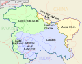 descriptive, non-topographic, SVG map
 -
 non-descriptive, topographic, SVG map


- Request
- Hello! I need an SVG map based off the info provided in the jpg CIA map above please. It is supposed to be a merger of maps 2 and 3 but with more detail. Thank you --𐩣𐩫𐩧𐩨 Abo Yemen (𓃵) 10:24, 7 May 2025 (UTC)
- This user is attempting to change a Wikiprojects India Pakistan China consensus of August 2019 for the topographic CIA map which was made by professional cartographers. They have impulsively come here. Fowler&fowler (talk) 10:29, 7 May 2025 (UTC)
- Yes it is. I have told you that I am going to start an RfC there, and Commons has nothing to do with this. I've already told you on that discussion that consensus can change. You already said that you aren't going to continue this discussion, but are now trying to do so on commons? 𐩣𐩫𐩧𐩨 Abo Yemen (𓃵) 14:41, 7 May 2025 (UTC)
- This user is attempting to change a Wikiprojects India Pakistan China consensus of August 2019 for the topographic CIA map which was made by professional cartographers. They have impulsively come here. Fowler&fowler (talk) 10:29, 7 May 2025 (UTC)
- Graphist opinion(s)
- Request taken by LápizRoto (talk) 11:32, 16 July 2025 (UTC)
Periplous of the Erythraean Sea
[edit]-
Periplous of the Erythraean Sea locations
Article(s): Very many articles.
- Request
- This is my second request regarding this image. It looks cluttered — dots, labels, and colors are all over the place. There's also a strange mist over the Indian Ocean. Could someone please work on this and improve it?--JamesMdp (talk) 04:26, 10 May 2025 (UTC)
- Graphist opinion(s)
- @JamesMdp This might be an explanation why it's hard to get someone to work on this.
- That file is not a true svg, there is a bitmap included in it (to show the topography, etc). The mist you are talking about is white to cover the bitmap so the legend is more legible. The svg file it self has a lot of clipped objects, so it's a really complicated file to edit or work in and then there are also several langues within the file.
- So for me, I would not edit or work on that file. My only solution would be to create a new map, a version of this and leave this as it is, then people can use which version they like. --please ping me-- Goran tek-en (talk) 17:50, 7 July 2025 (UTC)
- Thanks... JamesMdp (talk) 09:43, 30 September 2025 (UTC)
Topographical Indexes of Survey of India
[edit]-
 Topographical Indexes of Survey of India

Article(s): Many. Please see Category:Maps by the Surveyor General of India
- Request
- Could someone please create a SVG (editable) version of this map, so we can know at once which map we already have? This was done for Switzerland, and it is very useful: File:Switzerland topo 25 sheets orig.svg from File:Topo 25 sheets orig.jpg. Thanks, --Yann (talk) 10:00, 13 July 2025 (UTC)
- Graphist opinion(s)
Extended content
|
|---|
I used File:India district map (de-facto).svg as my base map and then I added File:Topographical Indexes of Survey of India 253k and 126k.jpg in it. In this image of them you can see that the coastline in File:India district map (de-facto).svg (red lines) does not fit with the jpg image.
|
@Yann I think you have to do a second thought about this request because you are changing what you want and that makes it impossible for me to do a good job.
- You have asked for a svg of that jpg file, then you changed to mostly "Himalaya", that's fine.
- You previously said you wanted the grid from the jpg and that I should follow its coastline/borders. But as I have said, that jpg and today maps doesn't add up. So then it's impossible for me to add that grid on to it. Why do you even have that jpg as a source.
- And now you want me to guess on where the borders should be.
I'm sorry, I really would like to do this, but right now I can't with the inconsistent information you provide. So please really think this thru and get back to me, if you haven't totally lost your belief in me, thanks. --please ping me-- Goran tek-en (talk) 17:36, 18 September 2025 (UTC)
- @Goran tek-en: Hi, Sorry if I was not clear.
- 1. Use modern borders, do not worry about the old borders.
- 2. We need the grid as close as possible like File:Topographical Indexes of Survey of India 253k and 126k.jpg, but only to find which sheet corresponds to which area. If it is easier, you could create 2 maps: one for Afghanistan and Pakistan, one for Northern India and Nepal. If the map covers a smaller area, there will be less discrepancy between older survey and new maps, and less distortion due to a different projection. Thanks again, Yann (talk) 19:06, 18 September 2025 (UTC)
- @Yann
- ----
- Those drafts are PNG versions of the original SVG file I'm working in and will upload to commons.
- Those drafts are shown for proofreading only.
- ----
- This map has nothing to do with any projection, perspective or likewise, I have edit it in any way possible to be able to get close to the grid in the jpg.
- Draft grid-1, this is what I have now and I want you to say if it's good so far.
- If you want me to add cities and other stuff you have to list it here; country/city (or other).
- --please ping me-- Goran tek-en (talk) 14:47, 21 September 2025 (UTC)
- @Goran tek-en: Hi, Yes, good. Is it possible to have the states borders? Yann (talk) 15:02, 21 September 2025 (UTC)
- @Yann
- This Draft grid-2 is with the state borders we have. I have toned down the rivers/lakes here, but all that can be changed as you like. And as before all those borders are edited and adapted to fit this map, which actually is more of an illustration than a map in some way. --please ping me-- Goran tek-en (talk) 15:11, 24 September 2025 (UTC)
- @Goran tek-en: Great, thanks. Yann (talk) 18:12, 24 September 2025 (UTC)
- @Yann
- Draft grid-3
- Should I remove numbers which doesn't touch any yellow area?
- Did you want any cities or other stuff?
- --please ping me-- Goran tek-en (talk) 11:49, 25 September 2025 (UTC)
- @Goran tek-en: Only the 92 number because it is not in the middle of the square. Yes, the major cities would be useful: Kabul, Karachi, Lahore, Delhi, Calcutta, Katmandu. Yann (talk) 17:25, 25 September 2025 (UTC)
- @Yann Draft grid-4
- You wrote before that this svg should be "editable" and I saw that the Switzerland map was uploaded with all layers which is unusual, so what do you mean?
- I also need to know how you actually are going to use this map; will you download it, then open it in an editor and color each "square" you have used or just take notes of the numbers, or how?
- It matters how I draw the "squares", thanks. --please ping me-- Goran tek-en (talk) 10:12, 26 September 2025 (UTC)
- @Goran tek-en: The objective is to update the map (or a copy of it) when sheets are uploaded. But I have never edited such a complex SVG file, so actually I don't know. I am open to suggestions. You can see in these categories which maps were already uploaded. I stopped uploading them when I realized that I need an index to keep track of what is already uploaded. Yann (talk) 19:30, 28 September 2025 (UTC)
- @Yann
- I have an idea how you could do but for that I need to upload the file, so I will need the following;
- Name of the file
- Description (/language)
- Captions/s (/language)
- Category/ies at commons
- Structured data/Items portrayed in this file, the Q#, to be able to upload it at commons, thanks.
- --please ping me-- Goran tek-en (talk) 11:54, 29 September 2025 (UTC)
- @Goran tek-en: File:Topographical Indexes of Survey of India.svg
- {{en|1=Topographical Indexes of Survey of India for 1:126,720 and 1:253,440 maps.}}
- Topographical Indexes of Survey of India for 1:126,720 and 1:253,440 maps / en
- [[Category:Survey of India 1:126,720 maps|0 Index]], [[Category:Survey of India 1:253,440 maps|0 Index]], [[Category:Index maps of India]]
- Q882247. Thanks again. Yann (talk) 14:12, 29 September 2025 (UTC)
- @Yann
- Now you can find it here file:Topographical Indexes of Survey of India.svg and in the description I have written how to change the background color in a "rectangle" to show that you have uploaded a sheet of that number.
- Really check so one understand how to do this, thanks.
- Please check all the information, also links for wikipedia, wikidata and structured data.
- If you are happy with this please put the code
"{{section re.solved|1=~~~~}}"(without the ".") on this request so it can be archived, thanks. Done
- --please ping me-- Goran tek-en (talk) 17:46, 29 September 2025 (UTC)
- @Goran tek-en: I had to install the "Edit SVG" script. OK it works. I expected to have a smaller grid, but OK. Thanks a lot again. Yann (talk) 19:29, 29 September 2025 (UTC)
- @Yann You can have smaller grid, but you haven't said anything regarding this before.
- Draft-5, this is 4 in 1 before, have to do the numbers something like this.
- Draft-6, another version
- --please ping me-- Goran tek-en (talk) 14:35, 30 September 2025 (UTC)
- @Goran tek-en: Ideally, I would like to have the same grid as File:Topographical Indexes of Survey of India 253k and 126k.jpg. Yann (talk) 15:57, 30 September 2025 (UTC)
- @Yann
- And to me it's not obvious which you want.
- Grid-4
- In this draft I have colored the different sizes so you can tell me which you want.
- The green ones could be numbered 33A... but it would be smaller font, the yellow ones are probably not a grid really and has no extra id on it.
- The blue ones doesn't either have an id but could be 331 332...
- If you want green or yellow I don't think I can do so could edit like I explained, too much work. So then you would probably have to install Inkscape, download the file, edit the background and then upload a new version.
- --please ping me-- Goran tek-en (talk) 16:14, 30 September 2025 (UTC)
- @Goran tek-en: Ideally, Green is needed for 253K maps and Yellow is needed for 126K maps. Now it may be too complex to have this level of details, and I could use the Green for both 253K and 126K maps (see 253K map of Peshawar (38 N) and 126K map of the same area (38 N NW). The 126K maps are named NW, NE, SW, SE for North-West, North-East, South-West, South-East). I will update 2 copies of the index, one for 253K maps, and one for 126K maps. Yann (talk) 16:47, 30 September 2025 (UTC)
- @Yann
- I don't really follow your thinking here, to me it has to be like this
- Red is 1 ID; 33
- Blue is 4 ID: 33NW, 33NE etc
- Green would be 16 ID; 33A, 33B etc
- Yellow would be 64 ID; 33ANW, 33ANE etc
- It would be a lot more work but if you have the time I can do it.
- It would mean you have to work in Inkscape as I explained and learn how to click/active the different paths (rectangles) as the will be on top of each other and not visible all the time (maybe they could if I use different width or something).
- You have to tell me which of the different colors you want, like; red, blue, green. Because I don't really understand if you need red and blue.
- We can do two different version so it will be easier for you to edit.
- red, blue, green
- red, blue, yellow
- It would mean you have to work in Inkscape as I explained and learn how to click/active the different paths (rectangles) as the will be on top of each other and not visible all the time (maybe they could if I use different width or something).
- --please ping me-- Goran tek-en (talk) 17:21, 30 September 2025 (UTC)
- @Goran tek-en: Yes, that would be great: one version with red, blue, green, and one version with red, blue, yellow. I have Inkscape installed on my laptop, and I have used it for very simple logos. Yann (talk) 17:39, 30 September 2025 (UTC)
- @Yann It will take some time as I have other things. --please ping me-- Goran tek-en (talk) 11:17, 1 October 2025 (UTC)
- @Goran tek-en: Yes, that would be great: one version with red, blue, green, and one version with red, blue, yellow. I have Inkscape installed on my laptop, and I have used it for very simple logos. Yann (talk) 17:39, 30 September 2025 (UTC)
- @Goran tek-en: Ideally, Green is needed for 253K maps and Yellow is needed for 126K maps. Now it may be too complex to have this level of details, and I could use the Green for both 253K and 126K maps (see 253K map of Peshawar (38 N) and 126K map of the same area (38 N NW). The 126K maps are named NW, NE, SW, SE for North-West, North-East, South-West, South-East). I will update 2 copies of the index, one for 253K maps, and one for 126K maps. Yann (talk) 16:47, 30 September 2025 (UTC)
- @Goran tek-en: Ideally, I would like to have the same grid as File:Topographical Indexes of Survey of India 253k and 126k.jpg. Yann (talk) 15:57, 30 September 2025 (UTC)
- @Yann You can have smaller grid, but you haven't said anything regarding this before.
- @Goran tek-en: The objective is to update the map (or a copy of it) when sheets are uploaded. But I have never edited such a complex SVG file, so actually I don't know. I am open to suggestions. You can see in these categories which maps were already uploaded. I stopped uploading them when I realized that I need an index to keep track of what is already uploaded. Yann (talk) 19:30, 28 September 2025 (UTC)
- @Yann Draft grid-4
- @Goran tek-en: Only the 92 number because it is not in the middle of the square. Yes, the major cities would be useful: Kabul, Karachi, Lahore, Delhi, Calcutta, Katmandu. Yann (talk) 17:25, 25 September 2025 (UTC)
- @Yann
- @Goran tek-en: Great, thanks. Yann (talk) 18:12, 24 September 2025 (UTC)
- @Goran tek-en: Hi, Yes, good. Is it possible to have the states borders? Yann (talk) 15:02, 21 September 2025 (UTC)
Out-of-date sailing conferences map
[edit]-
 Current map, depicting six conferences

Article:
- Request
- Since this map was created, the NWICSA has spun off and become its own conference. See the current conferences here. Thank you! Additionally, maybe this map could be converted to SVG? —BhamBoi (talk) 03:59, 15 July 2025 (UTC)
- Done BorysMapping (talk) 07:46, 16 July 2025 (UTC)
- Sorry to reopen this, but I just realized that the NWICSA conference was dissolved soon after its creation, and no longer exists. Would it be possible to have another version of the map that does include it for historical purposes while keeping a version without it? Sorry for the confusion with my original request and thank you in advance for any updates! BhamBoi (talk) 02:44, 17 July 2025 (UTC)
- I reverted the upload, not sure if there is a reason to make a copy? if you want you can copy my edit and upload it as a new file. BorysMapping (talk) 07:54, 30 July 2025 (UTC)
- Sorry to reopen this, but I just realized that the NWICSA conference was dissolved soon after its creation, and no longer exists. Would it be possible to have another version of the map that does include it for historical purposes while keeping a version without it? Sorry for the confusion with my original request and thank you in advance for any updates! BhamBoi (talk) 02:44, 17 July 2025 (UTC)
- Graphist opinion(s)
Correct label in Nouvelle-France map-ru
[edit]
Article(s): [[]]
- Request
- Per File talk:Nouvelle-France map-ru.svg there is a request to replace text "по Утрехтскому" in the label in the legend with "по Утрехскому" --Jarekt (talk) 14:50, 22 July 2025 (UTC)
- @Jarekt: Am I missing something or the legend already contains the text "по Утрехскому". BorysMapping (talk) 11:36, 7 August 2025 (UTC)
- BorysMapping, Thank you f☁or looking into it. The original request by User:БатлМаг was "в русскоязычной версии вместо"по Утрехтскому" написано "по Утрехскому" (пропущена буква т). Это простоязычная версия, везде в статьях вики договор называется Утрехтский". I guess I misunderstood the request, as my understanding of Russian is not very good and Google translation was also confusing. I think now the request was to change "по Утрехскому" to "по Утрехтскому". --Jarekt (talk) 01:10, 9 August 2025 (UTC)
- yes, indeed, otherwise current version is a colloquionism БатлМаг (talk) 08:15, 9 August 2025 (UTC)
- BorysMapping, Thank you f☁or looking into it. The original request by User:БатлМаг was "в русскоязычной версии вместо"по Утрехтскому" написано "по Утрехскому" (пропущена буква т). Это простоязычная версия, везде в статьях вики договор называется Утрехтский". I guess I misunderstood the request, as my understanding of Russian is not very good and Google translation was also confusing. I think now the request was to change "по Утрехскому" to "по Утрехтскому". --Jarekt (talk) 01:10, 9 August 2025 (UTC)
I have changed and uploaded a new version, all texts are outline so I couldn't see which font that was used. ![]() Done --please ping me-- Goran tek-en (talk) 16:19, 30 August 2025 (UTC)
Done --please ping me-- Goran tek-en (talk) 16:19, 30 August 2025 (UTC)
- LGTM, Thanks! БатлМаг (talk) 08:12, 3 September 2025 (UTC)
- @БатлМаг Then please put the code here so it can be archived, thanks. --please ping me-- Goran tek-en (talk) 14:35, 14 September 2025 (UTC)
- Sorry, I don't understand, but it was you, @Goran tek-en who made the changes? I only added code to request changes:
- :::== {{edit request}} == :::(for Russian labels) в русскоязычной версии вместо"по Утрехтскому" написано "по Утрехскому" (пропущена буква т). Это простоязычная версия, везде в статьях вики договор называется Утрехтский (https://ru.wikipedia.org/wiki/%D0%A3%D1%82%D1%80%D0%B5%D1%85%D1%82%D1%81%D0%BA%D0%B8%D0%B9_%D0%BC%D0%B8%D1%80%D0%BD%D1%8B%D0%B9_%D0%B4%D0%BE%D0%B3%D0%BE%D0%B2%D0%BE%D1%80_(1713)) :::
- Is this what you were asking for? БатлМаг (talk) 05:40, 26 September 2025 (UTC)
- @БатлМаг Then please put the code here so it can be archived, thanks. --please ping me-- Goran tek-en (talk) 14:35, 14 September 2025 (UTC)
This is what I mean:
Cannabis maps
[edit]

Article(s): en:Legality of cannabis, en:Cannabis in the Czech Republic
- Request
Can someone please change the Czech Republic to orange on the first map (File:Map-of-world-cannabis-laws.svg) and green on the second (File:Legality of Cannabis in Europe.svg)? Cannabis is not currently legal in the Czech Republic but is decriminalised. It won't be legalised until 1 January 2026, then it can be changed to blue, but it shouldn't be blue on either map now. Helper201 (talk) 12:33, 19 August 2025 (UTC)
- You left this message on my talk page, and I explained that both maps display laws that haven't yet come into effect. The same was done with previous jurisdictions and is consistent with other cannabis-themed maps such as those of the United States. --Ratherous (talk) 22:44, 19 August 2025 (UTC)
- And as I explained, consistency does not make anything correct. The map is displaying wrong information. That is factually correct to say. It doesn't matter how many times you do something wrong; it will always be wrong. Neither this map nor any other should be displaying information that is not currently factually correct. How is a Wikipedia reader (i.e. a non-editor) supposed to know which laws are current and which are future looking at these maps? They can't. Therefore, I posted here because you seemed unwilling to make this change and we seemed to be at an impasse. Helper201 (talk) 16:42, 20 August 2025 (UTC)
- If you would like to change the policy the maps follow you would have to have a discussion regarding doing so for both of those maps, not unilaterally demand someone makes changes for you. Also the Wikipedia articles do indeed expand on dates the laws come into effect, so the readers do very much have access to this information. Not to mention, one of the maps is literally a map I created and uploaded. --Ratherous (talk) 17:03, 20 August 2025 (UTC)
- And where has such a "policy" been formed in the first place and where would it be changed? I have "demanded" nothing, I made a request. I don't see anywhere on these maps where it states that the legalisation for the Czech Republic hasn't actually happened yet. Finally, you might like to read en:WP:OWN.
- Also, Mexico is flat-out wrong. Cannabis is decriminalised in Mexico, not legalised. Helper201 (talk) 04:02, 26 August 2025 (UTC)
- There has been a consistent pattern not only with this map, but as I mentioned previously, with other cannabis-themed maps from other regions with numerous precedents from previous jurisdictions legalizing the substance. Again, this is not exclusive to cannabis-themed maps, but also certain other legal visualizations, an example of which I have previously provided for you. I hope you realize Wikipedia and Commons are different projects and en:WP:OWN differs from COM:OWN. I don't think me inviting you to engage in a discussion over this issue in any way exhibits over-possessiveness over my upload in a manner that is contrary to COM:OWN. All files on Commons have talk pages, similarly to WP articles, which would, of course, be the appropriate location for a discussion. Your comment regarding Mexico would likewise be appropriate on the map's talk page - considering you provide sources and clearly back-up your claim, someone is very likely to respond either in favour or in opposition relative to the provided arguments. As you said yourself, "Therefore, I posted here because you seemed unwilling to make this change and we seemed to be at an impasse." Once you received push-back regarding your request on one user's talk page, your immediate reaction was to repeat your request elsewhere rather than opt for a wider discussion on the map's talk page - I'm not sure how not to perceive that as a demand over all else. Being at an "impasse" over content-related issues would be an appropriate point to start a wider discussion on both WP and on Commons. --Ratherous (talk) 01:27, 28 August 2025 (UTC)
- If you would like to change the policy the maps follow you would have to have a discussion regarding doing so for both of those maps, not unilaterally demand someone makes changes for you. Also the Wikipedia articles do indeed expand on dates the laws come into effect, so the readers do very much have access to this information. Not to mention, one of the maps is literally a map I created and uploaded. --Ratherous (talk) 17:03, 20 August 2025 (UTC)
- And as I explained, consistency does not make anything correct. The map is displaying wrong information. That is factually correct to say. It doesn't matter how many times you do something wrong; it will always be wrong. Neither this map nor any other should be displaying information that is not currently factually correct. How is a Wikipedia reader (i.e. a non-editor) supposed to know which laws are current and which are future looking at these maps? They can't. Therefore, I posted here because you seemed unwilling to make this change and we seemed to be at an impasse. Helper201 (talk) 16:42, 20 August 2025 (UTC)
- Graphist opinion(s)
Age of majority
[edit]
Article(s): en:Age of majority
- Request
- Some of the colours used for the ages on this map are too similar to each other and could cause problems for people with colour-blindness and other sight related issues. Specifically, the ages for 15/16 and 21 are very similar (seem to both be shades of orange) and the ages of 19 and 20 are also very similar in that they are both shades of blue. I would propose more distinct colour differences and would recommend changing the age of 21 to black and 20 to red. Helper201 (talk) 23:27, 26 August 2025 (UTC)
![]() Request taken by cmglee – Agreed that the colours should be updated. Having brownish colours for both lowest and highest values may confuse readers. Additionally, as the map is mostly green, that colour's saturation can be decreased. However, the map is used on many articles and updating legends will need much work. cmɢʟee ⋅τaʟκ 15:21, 28 August 2025 (UTC)
Request taken by cmglee – Agreed that the colours should be updated. Having brownish colours for both lowest and highest values may confuse readers. Additionally, as the map is mostly green, that colour's saturation can be decreased. However, the map is used on many articles and updating legends will need much work. cmɢʟee ⋅τaʟκ 15:21, 28 August 2025 (UTC)

Recoloured and legend added - @Helper201: Is this better?
cmɢʟee ⋅τaʟκ 14:30, 29 August 2025 (UTC)

- @Cmglee: its definetly better. However, I think it needs at least one change. <16 is very vague (could be anything from 0 to 15) and there is only one country among these that sets an age lower than 16 that I could find and that's Indonesia. I'd recommend setting a new colour for 15 and marking this in the key to be clearer and then "<16" in the key can be simple changed to "16". Maybe use black for 15 and "LightSlateGray" for 16? Helper201 (talk) 17:43, 1 September 2025 (UTC)
- @Helper201: It is no vaguer than the original, which states "age 16 or younger". Nevertheless, if it is indeed true that only Indonesia is lower than 16, I'll make the change. Can someone please confirm?
- Thanks, cmɢʟee ⋅τaʟκ 19:24, 1 September 2025 (UTC)
- @Cmglee: my apologies, I didn't mean to say that you made it worse, just that it could be made better than it was in the first place (i.e. before it was changed) by being less vague. Regarding Indonesia being the only country under 16, see here. Helper201 (talk) 19:38, 1 September 2025 (UTC)
- @Helper201: No worries, and thanks for clarifying.
- Delving deeper into the question, 2001:1970:56df:7d00:d09e:3d3:80f8:7257 (talk · contribs) removed Yemen from the age-15 category in this edit. The previous reference is now invalid.
- http://worldpopulationreview.com/country-rankings/age-of-majority-by-country still states that it's 15 but cites Wikipedia. Would you be able to find an authoritative source for Yemen, please?
- Thanks, cmɢʟee ⋅τaʟκ 12:01, 2 September 2025 (UTC)
- P.S. The article cites a "Constitution ot the Yemeni Republic" which states "3 - Age of Majority: eighteen full calendar years." http://natlex.ilo.org/dyn/natlex2/natlex2/files/download/83560/YEM83560.pdf concurs, so I've moved Yemen to age 18.
- Re colours, I made age 15 black and age 16 dark blue so that the colours get darker away from 18. cmɢʟee ⋅τaʟκ 12:16, 2 September 2025 (UTC)
- @Cmglee: my apologies, I didn't mean to say that you made it worse, just that it could be made better than it was in the first place (i.e. before it was changed) by being less vague. Regarding Indonesia being the only country under 16, see here. Helper201 (talk) 19:38, 1 September 2025 (UTC)
- @Cmglee: its definetly better. However, I think it needs at least one change. <16 is very vague (could be anything from 0 to 15) and there is only one country among these that sets an age lower than 16 that I could find and that's Indonesia. I'd recommend setting a new colour for 15 and marking this in the key to be clearer and then "<16" in the key can be simple changed to "16". Maybe use black for 15 and "LightSlateGray" for 16? Helper201 (talk) 17:43, 1 September 2025 (UTC)
Typos
[edit]-
 Italian A5 highway

Article(s): fr:Autoroute A5 (Italie)
- Request
- Hello,
Could you please correct a few typos on this map? There are some spelling mistakes in the names:
- Vallée [capital V]
- "Tunnel Suse de Fréjus" > "Suse [line break] Tunnel du Fréjus"
Thank you very much for your help! --Tenam2 (talk) 13:46, 27 August 2025 (UTC)
- Graphist opinion(s)
- Request taken by Ikonact (talk) 14:10, 27 August 2025 (UTC)
- @Tenam2, I corrected what you requested. Please let me know. --Ikonact (talk) 14:10, 27 August 2025 (UTC)
- @Ikonact Hi! Thank you for your quick reply. I would though need you to please correct one little detail, because it has to be "Suse [line break] Tunnel du Fréjus", and not "Tunnel [line break] Suse du Fréjus". Thank you in advance for your patience :) Tenam2 (talk) 12:57, 29 August 2025 (UTC)
- @Tenam2 done, and sorry for not doing it earlier. Ikonact (talk) 20:05, 29 August 2025 (UTC)
- No worries :) @Ikonact: Just a little last typo, as I wrote it should be "Tunnel du Fréjus", not "Tunnel de Fréjus". Thanks again :) Tenam (talk) 11:43, 1 September 2025 (UTC)
- @Tenam, @Tenam2: sorry, should be OK now.(I need to read better :-)) Ikonact (talk) 16:44, 1 September 2025 (UTC)
- No worries, thank you! Tenam (talk) 09:52, 2 September 2025 (UTC)
- @Tenam, @Tenam2: sorry, should be OK now.(I need to read better :-)) Ikonact (talk) 16:44, 1 September 2025 (UTC)
- No worries :) @Ikonact: Just a little last typo, as I wrote it should be "Tunnel du Fréjus", not "Tunnel de Fréjus". Thanks again :) Tenam (talk) 11:43, 1 September 2025 (UTC)
- @Tenam2 done, and sorry for not doing it earlier. Ikonact (talk) 20:05, 29 August 2025 (UTC)
- @Ikonact Hi! Thank you for your quick reply. I would though need you to please correct one little detail, because it has to be "Suse [line break] Tunnel du Fréjus", and not "Tunnel [line break] Suse du Fréjus". Thank you in advance for your patience :) Tenam2 (talk) 12:57, 29 August 2025 (UTC)
Degoogling of funicular derailment map
[edit]-
 Done
Done

Article(s): 2025 Ascensor da Glória derailment (Q136090574)
- Request
- I request that this map published by the Portuguese public agency GPIAAF be traced over using OpenStreetMap (or another free alternative) and vectorised. it likely fails as copyvio, however, passing it through here before submitting it to deletion. --Juwan (talk) 23:35, 9 September 2025 (UTC)
- Graphist opinion(s)
- Request taken by cmglee: Failing to find any free aerial photographs showing the route, I'll use OSM. cmɢʟee ⋅τaʟκ 10:02, 10 September 2025 (UTC)
- Done @Juwan: File:Gloria_funicular_accident_map.svg is ready for translation into other languages. cmɢʟee ⋅τaʟκ 17:21, 10 September 2025 (UTC)
File:State positions Iraq war.svg Please correct the missing content in this map.
[edit]-
 I found that there were some missing in this map. Six countries including Luxembourg, the Republic of Ireland, Cyprus, Armenia, Burma and Cambodia, together with Germany, France, Greece, Russia, China, Vietnam and other countries, opposing the Iraq War. I suggest changing the colors of the six countries including Luxembourg, the Republic of Ireland, Cyprus, Armenia, Burma and Cambodia to the same blue color as those of Germany, France, Greece, Russia, China and Vietnam.

Article(s): Iraq–European Union relations#Divisions in the approach to 2003 Iraq war, International reactions to the prelude to the Iraq War and Legality of the Iraq War
- Request
- I found that there were some missing in this map. Six countries including Luxembourg, the Republic of Ireland, Cyprus, Armenia, Burma and Cambodia, together with Germany, France, Greece, Russia, China, Vietnam and other countries, opposing the Iraq War. I suggest changing the colors of the six countries including Luxembourg, the Republic of Ireland, Cyprus, Armenia, Burma and Cambodia to the same blue color as those of Germany, France, Greece, Russia, China and Vietnam. Thanks. --Boston Mayflower (talk) 13:15, 12 September 2025 (UTC)
- Graphist opinion(s)
Correcting names
[edit]Article(s): File:Karte Sesvennagruppe.png
- Request
- This image uses the less common German names for Lower Engadine towns along with the Romansh ones. Specifically, "Fetan" is more commonly known as "Ftan" and "Schuls" more commonly as "Scuol". Can this be standardized to use the Romansh names i.e replace "Fetan" with "Ftan" and "Schuls" with "Scuol"? --Jo-Jo Eumerus (talk) 09:55, 22 September 2025 (UTC)
- Graphist opinion(s)
Silk Route Map
[edit]-
 Silk Route

.jpg)
.jpg)
.svg)
.jpg)
.jpg)
Article(s): en:Trade, en:History of India etc.
- Request
- [On the map] Differentiate between continent name (e.g., Europe) and country names (e.g., Somalia, India, Persia, Java, Arabia etc.). One label (Mediterranean Sea) is not straight. Please reduce the thickness of the blue and red lines, if possible. Thanks!
--JamesMdp (talk) 09:38, 30 September 2025 (UTC)
- Graphist opinion(s)